
Home | The Lakes | Calendar | News & Business | Membership | Merchandise | About | Contact | Resources
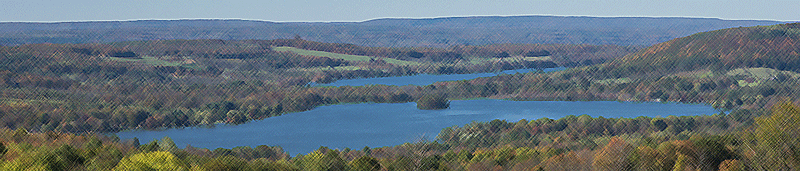
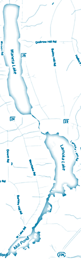 Waneta Lake lies north of Lamoka and are connected by a half mile long channel which is part of the Waneta Lamoka Wildlife Management Area. Both lie east of Keuka Lake, however, they are not considered a Finger Lake because they do not drain north, but south to the Cohocton River. Most of Waneta and Lamoka Lakes are located in Schuyler County. The western shore of Waneta and a small part of Lamoka, called Mill Pond, are in Steuben County. Lamoka Lake is named for the Lamoka Indian Nation that once populated the area between Lamoka and Waneta Lakes.
The half mile channel connecting the two lakes is owned by New York State Electric & Gas (NYSEG). These lakes once supplied water to a NYSEG hydro-electric power plant on the east shore of Keuka Lake which was fed from the north end of Waneta Lake through a pipe system. NYSEG was granted a non-power license in the late 1990s and since then the lakes water level is controlled by a NYSEG dam and spillway located at the south end of Mill Pond. The Federal Energy Regulatory Commission mandates a depth control limit of 1099 to 1096 feet, with a summer limit from Memorial Day to October 1st of 1099 to 1098 feet.
Lamoka has two true islands and a third which is attached by a permanent road. Weller Island, adjacent to Fleet's Cove, at the south-east end was connected by a road in the early 1950s. Red Bank Island is located at the northwest end of the lake and privately owned Stingers Island is located where the Mud Creek channel begins.
Both lakes have a good forage base, including a very large population of alewives or sawbellies, enabling most predator species to grow to very respectable sizes. Two of the most sought after species in the lakes are largemouth and smallmouth bass. Waneta Lake's populations are pretty evenly divided. Lamoka Lake's largemouth bass are more prevelant to smallmouth. Both lakes offer great fishing opportunities for anglers.
Waneta Lake is shallower than Lamoka Lake and its bottom drop-off is much more gradual. Boaters need to be more cautious when approaching the shoreline. Access to Waneta Lake is easier due to the open area surrounding the uniform shape of the lake and the paved highways along either side. Both lakes are accessible by a boat launch where County Road 23 crosses the channel connecting the two lakes.
Boat Launch Site
Lamoka and Waneta Lakes are accessed by a DEC launch site, 265 County Road 23, Bradford, NY 14815. Two miles west of Tyrone. These launch sites are on either side of a County Road 23, giving access to the channel connecting Lamoka and Waneta Lakes. Most low-profile boats are able to go from one lake to the other under the bridge. There is a parking area adjacent to the launch sites.
Plant Life - Waneta Lake
Extensive rooted aquatics are found in water up to 20 feet deep. Algae blooms occur regularly in summer causing turbidity. The southern end of the lake is shallow and generally classified as a wetlands area.
Plant Life - Lamoka Lake
Extensive rooted aquatics are found in water up to 20 feet deep, except along the north-east shoreline. Algae blooms occur regularly in summer causing turbidity.
Aquatic Life - Lamoka and Waneta Lakes
Bass, Largemouth; very common; growth rate excellent
Bass, Smallmouth; common; growth rate fair
Black Crappie; common; growth rate good
Bluegills; common; growth rate good
Brown Bullhead; common; growth rate good
Carp; common; growth rate excellent
Chain Pickerel; common; growth rate excellent
Muskellunge; uncommon; growth rate excellent
Pumpkinseeds; common; growth rate good
Red Bellied Sunfish; rare; growth rate good
Rock Bass; common; growth rate good
White Catfish; rare; growth rate good
Yellow Perch; common; growth rate good
Physical Characteristics - Waneta Lake
Area: 781 acres
Shoreline: 6.8 miles
Elevation: 1099 feet
Maximum Depth: 29 feet
Mean Depth: 15 feet
Bottom Type: mud / gravel
Physical Characteristics - Lamoka Lake
Area: 826 acres, including Mill Pond near Bradford
Shoreline: 11.3 miles
Elevation: 1099 feet
Maximum Depth: 40 feet
Mean Depth: 20 feet
Bottom Type: mud / gravel
Chemical Characteristics - Lamoka and Waneta Lakes
Water Clarity: turbid
pH: alkaline
Oxygen: poor in summer below 10 feet at the south end, not affecting fish
PO Box 55, Tyrone, NY 14887
The LWLA is a 501(c) (3) organization (non-profit tax exempt organization)
Sunday, June 23, 2024 | All blue text areas are hyperlinks